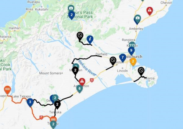
Waka Kotahi NZ Transport Agency is aiming to open SH1 south of Christchurch through Dunsandel and also at Hinds, south of Ashburton, on Tuesday – possibly in the afternoon.
“There is still up to 500 mm of water over the highway at the Selwyn River/ Waikirikiri bridge, but by Tuesday crews should be ready to clear debris and reopen the highway,” says Tresca Forrester, Journey Manager, Waka Kotahi NZ Transport Agency.
Other changes since the lunchtime update include:
A serious crash at Greta Valley, SH1, south of Cheviot, has closed SH1 at that point. With Route 70 through Waiau to Kaikōura also closed by the Hurunui District this afternoon, drivers either side of Greta Valley may have a delay tonight.
SH73 closure now starts at Springfield and goes through to the Porter River bridge. “Waka Kotahi crews from both Canterbury and the West Coast will be working to rebuild the abutments at the Porter River bridge once the river levels have dropped. We are hoping by Thursday we will have SH73 open to a single lane in a number of places,” says Ms Forrester.
Shingle spread over the road near the Porter River bridge also needs to be cleared in coming days. The bridge itself has been assessed and is not damaged apart from the guardrail.
SH75 the Akaroa highway is closed between Barrys Bay and Birdlings Flat.
The Ashburton River Bridge, SH1, remains open and river levels are slowly dropping. Police closed the two pedestrian walkways this afternoon for safety reasons.
SH8 to Fairlie from Timaru has now reopened.
SH8 Burkes Pass, Fairlie to Tekapo has reopened.
SH79 Geraldine to Fairlie is now open. However Rangitata to Geraldine is staying closed overnight with debris being cleared Tuesday.
Traffic and travel map(external link)
South Island Facebook page(external link)
“Many local roads are also under water, so your local council’s Facebook pages and Emergency Management pages are the best places to check.”
Up-to-date traffic map(external link)
https://www.facebook.com/HurunuiDistrictCouncil/(external link)
https://www.facebook.com/WaimakaririDistrictCouncil/(external link)
https://www.facebook.com/ChristchurchCityCouncil/(external link)
https://www.facebook.com/AshburtonDC/(external link)
https://www.facebook.com/TimaruDC/(external link)
Current situation as at 4.30pm, Monday 31 May(external link)

View larger image [JPG, 52 KB]
Plan ahead for a safe, enjoyable journey. Keep up to date with: