
Last updated: 17 December 2021
General
- What is the Nelson Future Access (NFA) Project?
The project is an investigation into the future transport requirements of Nelson. There have been several years of work, including two phases of public consultation. The project team has now recommended an integrated plan that takes into account all transport users. The recommended programme is designed to create better and safer journeys for all, encouraging those who can to consider public transport, cycling and walking.
Close
- Why do we need a change to the transport system in Nelson?
We want to ensure that Nelson’s transport system supports the future of this city, especially as the population of the region grows. This project is aligned with Nelson City Council’s priorities around infrastructure, the environment and city centre development, as well as the focus on urban intensification identified in the Nelson Tasman Future Development Strategy. We are also working to achieve the goals of the Government, which place greater focus on safety, accessibility, resilient and liveable cities, and the environment.
Close
- When will this investigation (business case) be completed?
This investigation is now complete following endorsement by Nelson City Council and the Waka Kotahi Board. Endorsement allows funding applications to proceed.
Close
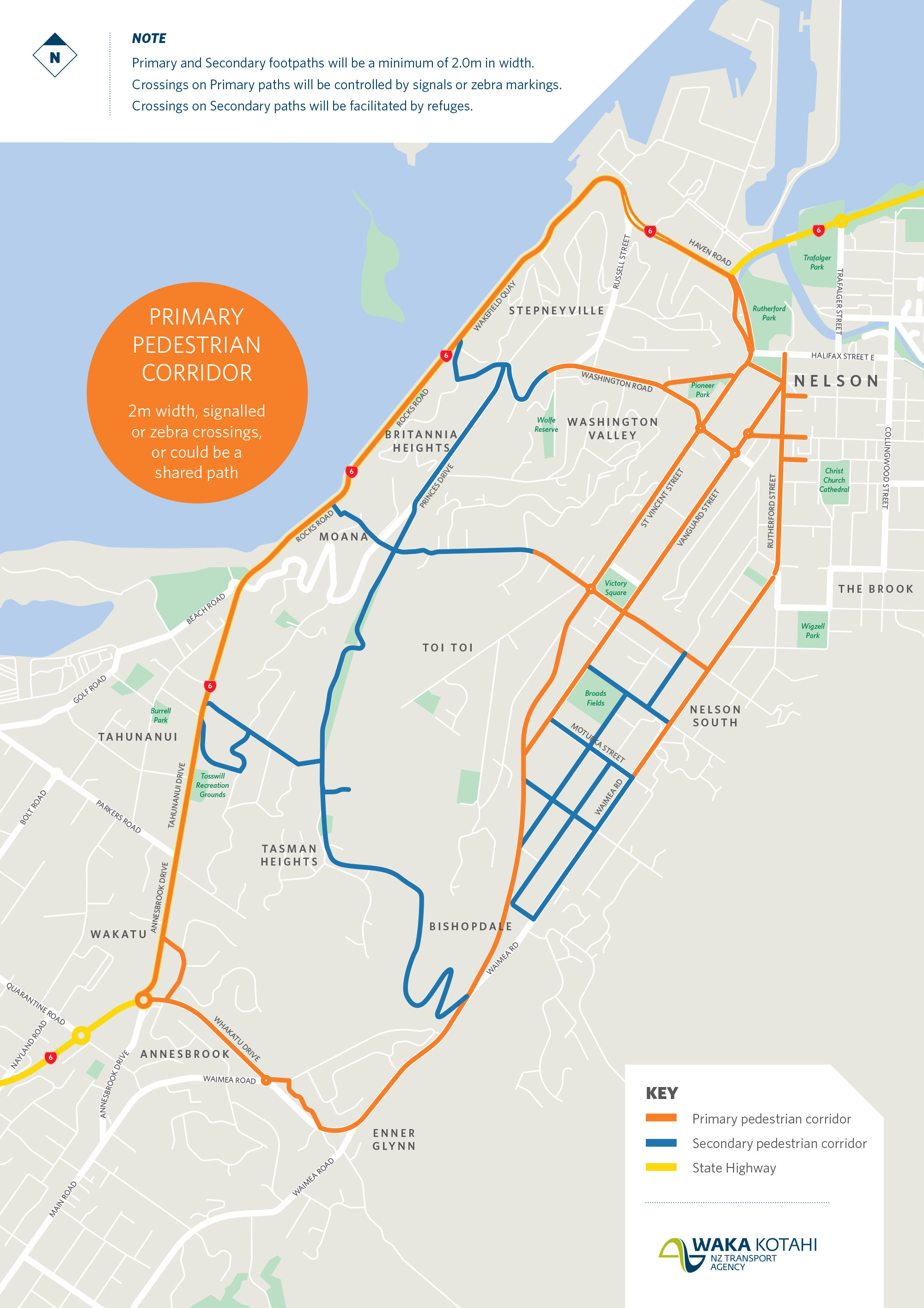
- What is the recommended programme?
The programme increases the availability of attractive walking and cycling paths and public transport options close to urban areas, focuses on reliable journeys to support regional economic development, improves safety for everyone and makes urban neighbourhoods more liveable. It includes a 5m boulevard along Rocks Road and proposes priority lanes in the longer term to encourage use of public transport.
View maps:
- Map of recommended programme excluding Rocks Road and Priority Lanes [PDF, 590 KB]
- Map of Rocks Road Walking and Cycling Detail [PDF, 567 KB]
- Priority Lanes (refined) map [PDF, 598 KB]
- How much is this investigation costing?
Since it began in 2018, $4.3 million has been allocated to the Nelson Future Access detailed business case.
Close
- Which areas are covered by the project?
The red area in the figure below is the project area.
The purple area represents the broader area of land use and travel demand that influences the issues and opportunities within the red project area.
Close
- Is the proposal resilient and does it take care of planning for climate change?
Our proposal is resilient. It takes account of current climate change forecasts and the transport changes proposed are designed to be fit for at least the next 30 years of transport demand.
Close
- How will carbon emissions be reduced?
Elements within the short-term package of measures will encourage the use of public transport, cycling and walking and ride sharing. The Preferred long-term package of Priority Lanes will encourage use of public transport. The whole programme of measures supports the urban intensification proposed in the Nelson Future Development Strategy. This puts people closer to the places they need to go and reduces carbon emissions.
Close
- Have you considered lower speed limits in Nelson?
We are recommending an area wide speed review of neighbourhood streets to make them safer and more liveable.
Close
- What’s the breakdown on cost for the Recommended Programme?
High-level estimated costs are:
-
- near-term 0-3yrs $28.3m
- short-term 4-10yrs $196.9m (including construction of Rocks Road walk and cycle)
- long-term 11-30yrs $200.1m.
Funding will only be sought once the proposal is finalised. Funding will most likely come through a mix of local and central government funding.
Close -
- The packages are a lot of money, are Nelson rate payers expected to fund the programme? If so, what does that mean for rates?
Funding would most likely come through a mix of local and central government funding. Most funding will only be sought once the final proposal is endorsed by the Waka Kotahi board.
Close
- Hasn’t our travel behaviour changed as a result of COVID-19?
Our most recent data shows the peak hour travel time is less variable in 2021 than in previous years and total volumes have slightly reduced. One factor in that could be an increase in the number of people working from home following the Covid-19 lockdown in 2020. The plan is flexible enough to take account of further travel behaviour changes.
Close
- We need to change where we are living rather than build more roads, what are you doing about that?
The Nelson Tasman Future Development Strategy proposes areas for intensification in existing neighbourhoods to enable people to live closer to the places they want to go. The short-term package is closely aligned and proposes to improve the walk, cycle and bus network to support the intensification.
Close
- How will you manage congestion?
The changes we are presenting are designed to encourage more people to walk, cycle and use public transport. The Priority Lanes are a flexible approach which can be configured to encourage bus use and also ride sharing. One of our short-term recommendations is to reinstate and make permanent the second southbound lane at Bisley Avenue on Tahunanui Drive to reduce a significant bottleneck at this location (see further question below about the reinstatement of the second southbound lane).
Close
Landowners
- Is Waka Kotahi looking to purchase properties now?
No. In the short-term, it is unlikely that properties will be needed with the exception of some Crown and port land associated with the Rocks Road walking and cycling project.
Close
- To what degree would properties be affected by the priority lanes?
The priority lanes solution does not include a median strip meaning that, in most locations, property requirements will be minimal. The most likely scenario is that the very front area of some properties (frontages) would be required in a small number of locations depending on the surrounding topography.
Close
- I think my property/business might be affected, who do I speak to?
Contact the project team: nelsonfutureaccess@nzta.govt.nz
Close
- When will you be talking more with specific landowners?
Further phases of work will include further design work before contact is made with property owners. Keep in mind that the timing of this work will depend on funding availability and other nationwide funding priorities and is not expected for at least 10 years. If Waka Kotahi NZ Transport Agency requires a property to construct a state highway project, purchase is done in accordance with the Public Works Act 1981. The Land Information New Zealand (LINZ) website has information on this process for property owners. We cannot comment on whether you should or should not purchase property in any given area. Nor can we comment on the future value of any property.
LINZ – Landowners’ rights(external link)
Close
Rocks Road Walking and Cycling Package
- What are you proposing along Rocks Road?
We are proposing a 5m walking and cycling path, which would be separated from traffic along Rocks Road. We would expect the existing seawall to be replaced at the same time as this walking and cycling path is built and for construction to take place within 10 years if a funding application to the National Land Transport Programme is successful.
Close
- When does the Rocks Road walking and cycling project start?
Our proposal takes into account the complex legislative framework for coastal marine areas, including the recently proposed ‘Outstanding Natural Landscape’ area identified in the Draft Whakamahere Whakatū Nelson Plan. Even so, design and consenting processes for a project like this would ideally start early to allow for appropriate detailed consultation and input from relevant authorities. We are proposing that construction takes place within 10 years, but this will depend on funding availability.
Close
- Why are you signalising the pedestrian crossing at Days Track?
Days Track is a popular walking track and a spot where people currently access the waterfront. Once the priority lanes long-term option is in place, there will be two lanes of regular traffic and a peak period clearway, so by signalising the crossing, pedestrians will have safer access across SH6.
Close
- Why have you recommended a revetment wall either side of the Outstanding Natural Landscape (ONL) adacent to Rocks Road and a vertical wall along the ONL?
The revetment wall type is considered a better defence against sea level rise and wave action. Along the ONL area, we are recommending a vertical wall because we must minimise the impact on the rocks that occur in this location and which are protected by the ONL.
Close
Short-term elements of the recommended programme
- What does the complete walking and cycling network look like?
We want all our packages to include these basic elements:
- Core cycling and pedestrian improvements to support land-use intensification, connect routes, and encourage more people to walk and cycle, which is better for their health and the environment (lower carbon) and take advantage of the emerging micro mobility trends such as e-bikes.
- Local area traffic calming measures to make our streets safer and our neighbourhoods more liveable.
- Intersection upgrades to support safer crossing and better vehicle movement including prioritisation of buses.
- Speed management on parts of the network to make our neighbourhoods vibrant places to live and safer for people walking and cycling.
- Marketing and promotion of different ways to travel to work and school.
- The programme supports:
- The recent proposal by Nelson and Tasman to improve the public transport service and reduce fares.
- The work underway by Nelson City Council considering how the parking regime can maintain city centre vibrancy and also encourage walking, cycling and using the bus.
Below are maps showing the walking and cycling networks. Note: some of the network shown in both maps is already constructed or under construction.
Close

- Is it possible that the short-term improvements will be enough and that we won’t need priority lanes?
Our modelling and analysis (which is based on the anticipated growth in the movement of people out to 2048) shows that short term options will address the existing problems in the transport system for the next 10–15 years and give time for people to take the opportunity to walk, cycle or use public transport were this is more practicable than taking the car. Beyond that, priority lanes will be needed out to 2048 to address the longer distance transport demand.
Close
- Why have you decided to reinstate the second southbound lane 24/7 on State Highway 6 at the Bisley Avenue intersection?
Modelling and observed congestion at this intersection demonstrates that it will increasingly operate as a bottleneck for traffic heading south on SH6 Rocks Road if the southbound lane is not reinstated. As the state highway, it is an important regional link between centres and the port. Nelson Future Access acknowledges that most people who provided us feedback on the proposal to enforce a peak hour clearway in this location, thought it would be dangerous or wanted parking to remain in front of medical services.
Following the community feedback two things have occurred:
-
- A safety assessment of the proposal has recommended that any confusion about the road space in front of the shops be removed by reinstating the southbound lane as a permanent traffic lane. i.e. 24/7 operation
- Nelson City Council has undertaken to explore carparking options in the vicinity of this critical intersection in recognition that the services, particularly the medical services, in this location are important to the Tahunanui community.
-
- What traffic calming measures are you recommending on Chamberlain Street?
The project team has not made a specific recommendation about traffic calming on Chamberlain Street. The feedback we received on traffic calming options for this street has been passed on to Nelson City Council to assist with design solutions.
Council has indicated it will be working with Tahunanui hillside residents on trialing speed control measures.
Close
Priority lanes
- When will we need to have the priority lanes in place?
Our modelling and analysis suggest that without significant changes in current demands, a long-term package is needed within the next 10–15 years.
Close
- Would cyclists be allowed in the priority lanes?
That decision will be made at the detailed design stage.
Close
- If I lived on the priority lane corridors could I still park outside my property?
During off peak periods you would be able to park, but not during peak traffic periods.
Close
- How would the priority lanes be enforced?
New technology and supportive legislation is most likely to be used to enforce compliance with the priority lanes.
Close
- Will you maintain the flush median along the length of the proposed priority lanes?
No, we propose that it will be removed to minimise the impact on private property.
Close
- Which priority lane route would be built first and how will it be staged?
These lanes are not proposed for 10-15 years. A decision on staging will be made closer to the construction phase.
Close