With significant growth predicted in Auckland’s north west over the next 30 years, the SH16/18 Connections project proposes a range of improvements between State Highway 16 (SH16) from Brigham Creek Road and State Highway 18 (SH18) to Squadron Drive (SH18).
Auckland’s north west is growing and is expected to more than triple in population over the next three decades. Most of the growth will occur initially in Hobsonville, Westgate, Redhills and Whenuapai, and from 2028 further growth will follow in Kumeū-Huapai. In total more than 75,000 people and 25,000 new jobs are expected by 2046.
The SH16/18 Connections project is an important component of the overall transport network plan to support this growth and will increase and improve access between the growth areas in the North West and the North Shore.
The project includes a range of improvements between SH16 from Brigham Creek Road and SH18 to Squadron Drive and aims to improve accessibility, reliability and travel choices for people travelling in the north west of Auckland.
The proposed improvements are only one part of an integrated transport system and will work together with the wider Supporting Growth Programme(external link) which includes future rapid transit corridors and extended walking and cycling links. The Supporting Growth Programme is a collaboration by Auckland Council, Auckland Transport and the NZ Transport Agency, and is investigating and planning a fully integrated 30-year transport network for all of Auckland’s future growth areas.
Although some aspects of the SH16/18 Connections project may be prioritised to be delivered early, the overall intention is to see long term route protection and plan to deliver these improvements over the next few decades, in line with growth and funding availability. Protecting the route for the areas needed for these improvements now will provide planning certainty for the community and landowners, and ensure land is available in the future when it is required.
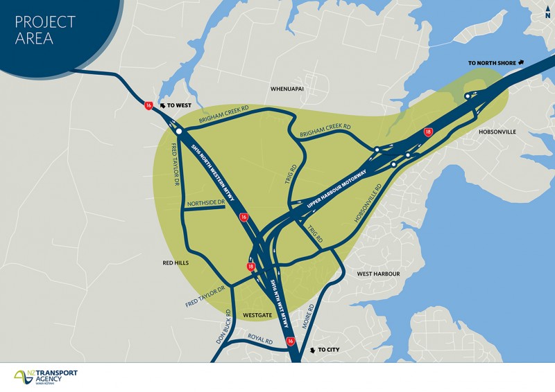
View larger map image [PDF, 553 KB]
The proposed improvements include:
The benefits of enhancing the transport network in this area are:
During 2018 we asked for feedback on the proposed improvements together with the North West Supporting Growth Programme. This combined approach enabled people to see and comment on the full picture of proposed transport networks needed to support future growth in the area over the next 30 years.
Overall, feedback to date has been supportive on the proposed improvements. Key feedback themes include ensuring clear integration with other infrastructure projects in the area, provision for walking and cycling facilities and managing potential environmental and social opportunities and effects. Read a summary of the feedback received [PDF, 230 KB]
The draft business case for the SH16/18 Connections project will be presented to the NZ Transport Agency Board for approval and is intended to be integrated with the wider North West Supporting Growth programme to ensure a well-coordinated approach to infrastructure planning for the area.
Although some aspects of the SH16/18 Connections project may be prioritised to be delivered early, the overall intention is to seek long term route protection and plan to deliver these improvements over the next few decades, in line with growth and funding availability. Route protecting these improvements now will provide planning certainty for the community and landowners, and ensure land is available in the future with it is required. For more information on route protection, visit the Supporting Growth Programme’s frequently asked questions(external link).