If your question is not answered here, please email us at awhc@nzta.govt.nz
About the project
Who is delivering this work?
Waka Kotahi NZ Transport Agency, in partnership with Ngā Iwi Mana Whenua o Tāmaki Makaurau, Auckland Transport and Auckland Council and an alliance with four companies - WSP, Beca, SYSTRA and COX Architecture - are working to progress an Indicative Business Case for this nationally significant project.
Why is it needed?
There is a long history of planning work for improvements to cross-harbour transport connections, with at least ten major studies conducted over the past 30 years.
At a regional level the growth of Auckland’s North Shore and the wider region is placing increasing pressure on the transport system. In addition, SH1 is a nationally strategic corridor and a key route for the nation’s freight, goods, and services.
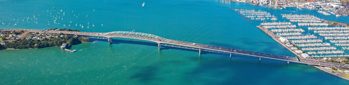
The current Auckland Harbour Bridge structure is coming under increasing operational pressure, affecting the resilience of the bridge and the wider network, and these pressures are forecast to increase further as population, employment and freight needs continues to grow. Ongoing regular maintenance is needed on the bridge structure, and unexpected incidents such as crashes and high wind events mean the bridge and wider network are increasingly compromised, causing widespread disruption to the transport system.
There are ongoing environmental and climate related considerations that this project will tackle when investigating options for new connections, especially relating to rising sea levels affecting the section of Northern Motorway from Esmonde Road to the Auckland Harbour Bridge.
The Auckland Harbour Bridge carries most major services and utilities, such as power, telecommunications and water and we will look at how we integrate these services into any new or existing infrastructure to continue to support these essential connections.
To provide more transport choice for people wanting to walk or cycle across the harbour, this project will investigate future long-term active mode connections to tie into the wider walking and cycling network. This will be a fully integrated approach and walking and cycling will be assessed along with all other modes to consider how to make the most of the existing and new infrastructure.
A second rapid transit connection, in addition to the successful Northern Busway, is needed to cater for increasing demand and to provide more travel choice as the North Shore grows.
What has the planning work involved so far?
The current planning phase – an Indicative Business Case (IBC) - has built on the 2018-2020 business case.
Part of the IBC process involves assessing a range of options and recommending a way forward for further development. For this project, this includes:
- evaluation of all transport modes – rapid transit in the form of light rail, connections for people on foot and bikes, vehicles and freight, along with the use of the existing Northern Busway for bus passengers
- options to look at the future use of the existing Auckland Harbour Bridge while also considering the form, function and route of new connections across the Waitematā Harbour
- ways to integrate transport improvements with the best urban land development and land use outcomes
- ensuring significant consideration is given to the Government and Aotearoa New Zealand’s commitment to reaching net zero emissions by 2050.
Project partners will integrate with Auckland Light Rail and other city shaping projects to ensure a fully integrated future transport system for Tāmaki Makaurau Auckland.
What will this project cost?
The potential cost of a future programme of work will be established during the current IBC planning phase.
This project will be one of New Zealand’s biggest transport investments in the coming years and is expected to involve significant design and construction work. The Government has indicated construction to start by 2029.
What if the port moves?
We’ve investigated a range of transport modes for this project, including freight. Approximately 5% of all heavy commercial vehicles using the crossing travels to and from the port. The crossing will remain a significant freight corridor regardless of the port’s location.
What’s next for the project?
Investigations are progressing to finalise the Indicative Business Case, which is due to be completed in early 2024.
When is the next opportunity to provide feedback?
The formal engagement period for the Indicative Business Case ran between March to May 2023. We’ll continue to talk with our partners and the community as the project progresses. There will be future community engagement as part of future phases.
The emerging preferred option
What are you recommending?
We’re recommending a way forward for this city-shaping project that can also be delivered in stages. Potential staging depends on many things including funding availability. The various elements of the project that will make up the stages are:
- upgrading the Northern Busway stations and constructing an active mode path between Constellation Drive and Akoranga Drive
- constructing roading tunnels for three lanes in each direction - between Akoranga Drive and the central motorway junction - to address resilience and allow for multimodal connections
- completing significant maintenance upgrades to the existing Auckland Harbour Bridge (AHB); raising SH1 to protect it from sea level rise inundation; constructing dedicated bus priority from the Akoranga Station across the AHB to the city centre; constructing a dedicated and protected active mode path from Akoranga Drive across the AHB (using eastern clip-ons) to the city centre.
- a new light rail tunnel from Wynyard Quarter to Albany, with stations at Belmont, Takapuna, Smales Farm, Glenfield, North Harbour, and Albany West.
Why is this the emerging preferred option?
Providing modern, high-quality, and resilient infrastructure is crucial for a thriving Tāmaki Makaurau. The emerging preferred option provides the best opportunity to do this, responding directly to key problems – resilience, a lack of transport choice, and future growth. This option will also allow for staging and provide new connections that help change the way people and goods, freight and services travel across Te Waitematā and the North Shore.
From an assessment perspective, this option performed the best against the various criteria, factors, and assessments. From a staging perspective, the recommended option allows for flexibility in accommodating growth and funding.
Why is resilience important?
We know that the ageing Auckland Harbour Bridge is vulnerable to accidents and extreme weather events, causing partial or full closures. This creates travel disruption and delays, as well as economic impacts for the movement of goods, freight and services. The bridge will soon need intensive, more frequent maintenance to keep it operational, which will mean more closures. Beyond the Auckland Harbour Bridge, parts of both the Northern Motorway and Northern Busway are susceptible to flooding, extreme weather events and ongoing sea level rise.
Resilience of Auckland’s transport network is a key objective of this project, and the solution addresses this by removing 60% of the traffic and freight from the bridge into the tunnels.
In addition, the solution raises the section of State Highway 1 between the Auckland Harbour Bridge and Akoranga to help protect against sea level rise. The new road tunnel will avoid disruption and closures caused by extreme weather events entirely and provides an alternative in the event of any incident.
Why are you adding more lanes of traffic – won’t that increase congestion?
There is no increase in the existing number of peak direction vehicle lanes. Currently, the Auckland Harbour Bridge has a moveable median barrier that allows for five lanes of peak flow traffic.
Under the recommended way forward, we’re shifting State Highway 1 general traffic into tunnels and reducing the current number of lanes on the existing AHB. State Highway through traffic will also largely be separated from traffic heading into and out of the city centre increasing overall efficiency.
What are you doing to encourage people to use other modes instead of their cars?
We’ll be reallocating lanes on the existing corridor for dedicated active modes and buses and will have the opportunity to re purpose some of the land used for the existing state highway. Two lanes of the Auckland Harbour Bridge will be converted to active mode lanes, and a further two will be converted to bus lanes that directly connect to the Northern Busway which will be extended into the city centre.
Another stage of the project will introduce light rail across Te Waitematā and to the North Shore. Connecting communities within walking distance to rapid transit stations will also allow for intensified development and better access to employment centres.
As part of an overall transport network approach that considers all modes together, this provides for an integrated solution that gives people choice and allows for a more resilient network and movement for all modes for years to come.
Will this project help lower emissions and vehicle kilometres travelled (VKT)?
New infrastructure is important to deliver alternatives to travelling by private vehicle. The solution more than doubles the capacity for sustainable travel across Te Waitematā in the future.
High quality alternative active and public transport will enable other policy changes to be considered – road pricing, parking charges, and targeted land use intensification – that further encourage the use of more sustainable transport modes.
The initial analysis of VKT and vehicle emissions impacts of the staged implementation of the project found:
- Annual CO2-e savings peaking at some 4,800 tonnes of CO2-e per year by 2051.
- Annual VKT savings of some 86 million km per year by 2065.
- Cumulative savings over the 25-year period (2041-2065) are estimated at some 82,000 tonnes of CO2-e and 1.1 billion km of vehicle travel.
- Initial analysis indicates that these savings purely from the transport infrastructure would be over 3 times greater with road pricing (e.g. tolling).
Combined with more transport choice across Te Waitematā and beyond, this will present a significant opportunity to help decarbonise our transport network.
Will the option remove the Victoria Park flyover?
The solution will remove the Victoria Park flyover.
Why isn’t there a new bridge being recommended?
Bridge options have significant cultural and environmental effects particularly in the approach sections. The proposed tunnel solutions across Te Waitematā give us the best opportunity to avoid these effects and fulfil the vision of a future transport network for Tāmaki Makaurau.
Tunnels respond directly to significant problems facing Tāmaki Makaurau – resilience, a lack of alternative forms of transport, and future growth. The existing bridge will be retained and improved to increase its life and provide multimodal access across Te Waitematā.
We’ll continue investigations into the final form and alignment of the tunnel in future phases of the project and look at what we’ve proposed in more detail.
Walking and cycling
What is happening with the proposed walking and cycling bridge in the short to medium term?
Waka Kotahi has considered lane reallocation on the Auckland Harbour Bridge on a number of occasions over recent years. In October 2021 the Minister of Transport invited Waka Kotahi to consider trialling lane reallocation to active modes on the bridge. Additional work carried out since 2021 has reinforced that safety and network impact issues associated with lane reallocation mean that it is not a preferable option.
Waka Kotahi gave advice on interim measures to the Minister of Transport in April 2022.
What will happen to walking and cycling in the longer term?
Waitematā Harbour Connections is recommending constructing an active mode path between Constellation Drive and Akoranga Drive initially.
This will be followed by construction of a dedicated and protected active mode path from Akoranga Drive across the Auckland Harbour bridge (using the eastern clip-ons) to the city centre after the new road tunnels are completed.
Rapid transit
What mode will the additional rapid transit connection be?
Early work suggested the additional rapid transit connection needed to be a rail-based mode. Only rail-based options provide enough additional capacity to meet the forecasted future demand.
With the recent decision on light rail for Auckland Light Rail and the integration between all rapid transit projects, the mode will likely be light rail.
What is rapid transit?
Rapid transit is a type of fast, frequent public transport that carries large numbers of people using a variety of modes including rail, metro and buses that operate on specially built corridors separated from other traffic, providing more reliable, uncongested routes.
Where will the additional rapid transit connection go?
While the previous business case identified the additional rapid transit connection should directly link the city centre with Takapuna and Smales Farm, extending to Albany, it will need to integrate with the Northern Busway and wider public transport network. Finalising route options for this new rapid transit connection is another key part of this phase of planning work.
What are the urban development opportunities?
An essential part of this project will be to recommend ways to integrate these transport improvements with quality urban development and land use outcomes. The places this project will pass through will become vibrant, diverse, centres and neighbourhoods, focused on quality transport routes, enabling people to have more choice in housing, employment, education, and other services.
How will you work with Auckland Light Rail and other projects around Tāmaki Makaurau Auckland?
While Auckland Light Rail and the Waitematā Harbour Connections are separate projects, together they underpin expansion of a rapid transit system. Both projects will integrate to consider the full Auckland transport system to better connect road, rail, bus, walking and cycling, encouraging quality growth, giving people more travel choices, making the transport network more resilient, and tackling congestion and harmful pollution.
Waitematā Harbour Connections will connect with Auckland Light Rail in the city centre providing seamless travel options between the North Shore and employment hubs at Auckland Airport and areas of housing growth in Mt Roskill, Onehunga and Mangere and with other future rapid transit corridors to the North-West.
How does rapid transit help shape the city’s growth?
Tāmaki Makaurau Auckland will significantly expand and upgrade its rapid transit network over the coming decades to support and shape the city’s growth.
An essential part of Waitematā Harbour Connections will be to recommend ways to integrate these transport improvements with quality urban development and land use outcomes. The places this project will pass through will become vibrant, diverse, centres and neighbourhoods, focused on quality transport routes, enabling people to have more choice in housing, employment, education, and other services.
Why aren’t you doing heavy rail instead of light rail?
There has been significant planning over many years into the development of Auckland’s public transport network and there are several key reasons why heavy rail (i.e. the current rail system operating in other parts of Auckland) isn’t being pursued for the North Shore. Heavy rail comes with larger costs and limited stageability potential to address North Shore demands and would require significantly greater infrastructure to regrade the area for heavy rail. Forecast demands are expected to be catered for by light rail with capacity to spare long into the future.
Have you looked into alternative public transport modes like gondolas or trackless trams?
There’s been a significant amount of work over many years to look at all the travel demands for people to move across Auckland, including which modes can best to serve those and can form a viable network. Modes such as ferries, gondolas, monorail, and newer ‘pod’ technologies tend not to have the necessary capacity or are yet to be considered ‘proven’ technologies appropriate for serving such a critical part of Auckland.