Port Marsden Highway to Whangārei is one of the 3 Roads of National Significance (RoNS) that make up the Northland Corridor, a 100-kilometre strategic route connecting Auckland to Whangārei.
Port Marsden Highway to Whangārei is one of the 3 Roads of National Significance (RoNS) that make up the Northland Corridor. These RoNS will support economic growth and productivity, reduce congestion, improve safety, support housing development, and provide a more resilient roading network.
The preferred route for Port Marsden Highway to Whangārei is part of the Investment Case that has been endorsed by the NZTA Board which covers the Northland Corridor between Te Hana and Whangārei.
The full corridor between Te Hana to Whangārei is moving to the route protection stage.
The preferred route is a refinement of the emerging preferred corridor. We will use this route to apply for consents and designation. There are still several places the final road may go within the preferred route.
The preferred route for Port Marsden Highway to Whangārei proposes:
We have used previous work done in the corridor and refined the emerging preferred corridor further to select the preferred route. This has included considering how we deliver to a RoNS standard and accounts for aspects such as:
The next steps are for the project team to work at pace to refine the preferred route further, by beginning geotechnical and environmental investigations.
We will now start to contact impacted landowners. Due to the 75 km length of the corridor between Te Hana to Whangārei, we will be engaging in individual meetings with landowners in stages. Further details will be provided in the individual letters sent to landowners.
The project expects to make use of the Fast-track Approvals Act as well as Public Works Act changes for critical infrastructure.
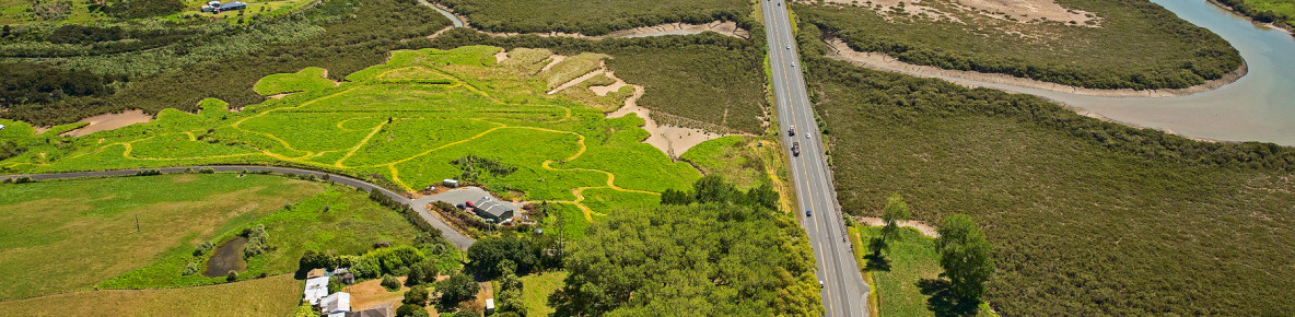
Long plot map
A long plot map shows the preferred route over a large area. It helps show how the project fits into the wider landscape. They are indicative only, and do not show the final area or where the new road will go.
Yellow dotted lines
Yellow dotted lines show the boundary of the preferred route, not where the final road will go.
Why the corridor looks wide
There are still many different places the final route may go within the preferred route. We are at the route protection stage, which means we are working towards protecting the land for future planning to build the road. The area we will protect needs to give room for further environmental and geotechnical investigations, innovation in future design, and allow for the extra area we will need during construction of the road, for things such as lay down areas, access, stormwater systems and other required mitigation areas.
Final area for route protection
The long plots do not show the final area we will be applying for route protection for.
We are currently undertaking geotechnical and environmental investigations as well as design development and having individual conversations with landowners to help us refine the corridor further. We expect to lodge the Notice of Requirements (NoR) to route protect the area for the Alternative to the Brynderwyn Hills by mid-2026 and for the remaining sections of the corridor by late 2026. We will share the updated maps when we lodge the NoR.
How to know if your property is affected
If a property you own is within the preferred route you should have received a letter from us.
We are meeting landowners in stages, starting with the Alternative to the Brynderwyn Hills section. If you’re not sure or have questions, please contact us.
Contact for property queries:
More information for landowners is available here:
SH1 Northland Corridor information sheet for landowners – October 2025 [PDF, 403 KB]
Close
All landowners within the preferred route should now have received their letter communicating this, and we have started to have individual meetings with landowners. Due to the 75 km length of the corridor, individual landowner engagement is occurring in a staged approach, beginning with potentially affected landowners in the Alternative to the Brynderwyns Hills section.
Landowners between Waipu and Whangārei will be contacted again early next year with further information to book in their individual meetings with the project team.
SH1 Northland Corridor information sheet for landowners – October 2025 [PDF, 403 KB]
Close
We will continue to work closely with our iwi and hapū partners and key stakeholders, and to share our progress with landowners and the community as we work at pace on the Northland Corridor project.

View larger timeline [PDF, 90 KB]
CloseIn April 2025, an emerging preferred corridor was announced for Port Marsden Highway to Whangārei.
To select the emerging preferred corridor we have taken all previous work done in the corridor into account, and looked at factors such as recent weather events, how the corridor performs as a whole, ground and soil conditions, and environmental and cultural impacts. These factors all feed into how much the road will cost and how it will be built.
The emerging preferred corridor proposes: